OTHER EASTBOUND ROUTES PRIOR TO 1928
HOW TO USE THESE CHARTS
Numbers indicate the mileage westbound from the control station, or zero point, at the east end of the subject section. All mileages are scaled from the quadrangle maps of the United States Geological Survey. The tourist must allow for small mileage corrections within each section because of the inherent accumulating errors of the typical car odometer.
Other routes prior to 1928
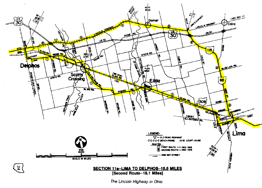
SECTION 11a1--DELPHOS TO LIMA via Scott's Crossing and Elida
SECTION 11a2--DELPHOS LIMA via Gomer and Ord's Corner
SECTION 10a--LIMA TO UPPER SANDUSKY
SECTION 9a--UPPER SANDUSKY TO BUCYRUS via Nevada
SECTION 7a--GALION TO MANSFIELD
SECTION 6a--MANSFIELD TO WOOSTER via Ashland
SECTION 11a1--DELPHOS TO LIMA Via Scott's Crossing and Elida Original route is16.6 MILES . Please follow this simplified version which is 15.0 miles. It is generally the 1940's version of U. S. Route 30-S. It is more direct and eliminates over a dozen turns.
0.0—From CONTROL STATION at DELPHOS, bear south with Main Street/State Route 66
0.2—At traffic signal, turn Left onto Second Street
0.6—At fork where Second Street angles Left, curve Right now with Elida Avenue
1.2—At stop sign, continue easterly now with Elida Road
3.0—Junction with State Route 309; continue easterly with Elida Road/State Route 309
4.2—SCOTT'S CROSSING
8.1—Angle Left onto Main Street in Elida, opposite Piquad Road railroad crossing, diverging temporarily from State Route 309
8.3—At stop sign in downtown ELIDA, continue easterly with Main Street
9.0—At stop sign, turn Left and resume easterly with State Route 309/Elida Road
13.2—Road curves south at railroad overpass and enters Lima on Jameson Avenue; old road remnants survive below as adjacent surface streets
14.0—At traffic signal, turn Left (east) onto West Market Street, diverging from State Route 309
14.5—Allen County Museum at Left
15.0—CONTROL STATION at LIMA is at the traffic signal in Town Square at the intersection of Main Street; this was the original intersection point of the Lincoln Highway and Dixie Highway in Ohio
SECTION 11a2--DELPHOS TO LIMA via Gomer and Ord's Corner 18.1 MILES
0.0—Continue easterly with Fifth Street
Follow charted course for Section 11 until reaching...
11.0—ORD'S CORNER; at stop sign at State Route 115, turn Right onto State Route 115
14.0—Junction with State Route 65; continue southerly with S.R. 65/West Street into Lima
17.2—At traffic signal at Grand Avenue, S.R. 65 diverges; continue southerly with West Street
17.5—At traffic signal and church, turn Left onto McKibben Street for two blocks
17.65—At stop sign, turn Right onto Main Street
18.1—CONTROL STATION at LIMA is at the traffic signal in Town Square at the intersection of Main Street; this was the original intersection point of the Lincoln Highway and Dixie Highway in Ohio
SECTION 10a--LIMA TO UPPER SANDUSKY 49.7 MILES
0.0—Continue easterly with Market Street
0.05—Lima's Lincoln Highway Garage was in the brick building with "Parking" sign at Right
0.5—At bridge over Ottawa River, angle Right onto Bellefontaine Avenue
0.8—Junction with State Routes 309 and 117; continue southeasterly with state routes, also with Bellefontaine Avenue
1.6—At traffic signal, angle Left onto Harding Highway, continuing easterly with state routes
2.0—At traffic signal, S.R. 117 diverges; continue easterly with Harding Highway/State Route 309
 12.0—MAYSVILLE
15.0—Turn Left with State Route 235 , leaving State Route 309
17.5—At traffic signal in ADA , Lincoln Street X's E-W; Post Office is at northwest corner
17.6—Old Pennsylvania Railroad caboose and station at Right
18.0—At traffic signal, turn Right onto State Route 81
21.1—At stop sign at County Road 75, turn Right across railroad tracks, then immediately Left, continuing with State Route 81
23.3—Historical marker for Hog Creek Marsh at Right
24.4—At fork in road, angle Left with State Route 81
25.1—At DOLA, turn Right, continuing with State Route 81
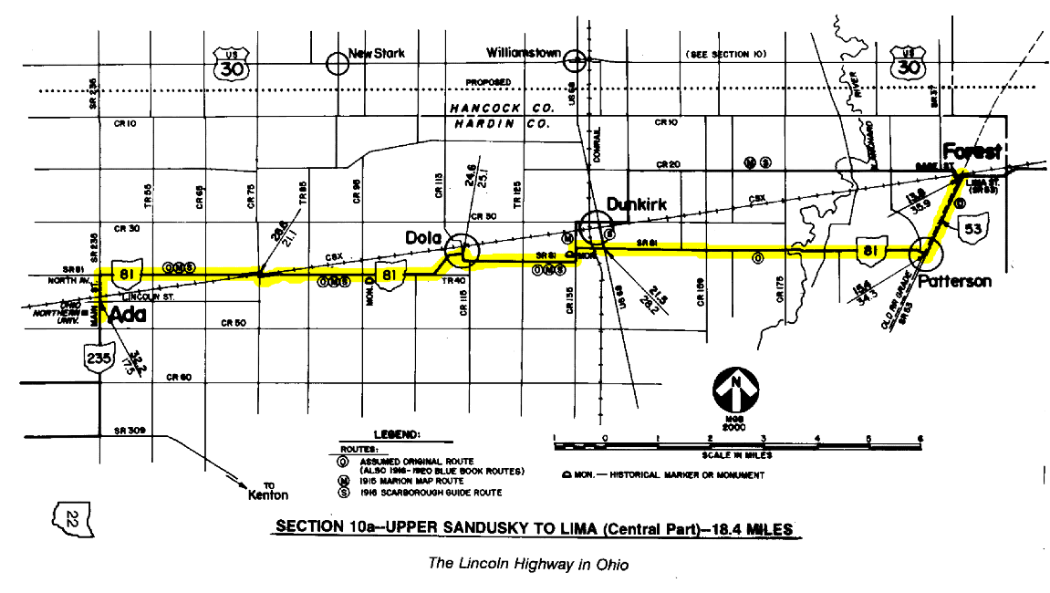 25.3—Turn Left thru sharp curve
27.4—At stop sign at County Road 135, turn Left, continuing with State Route 81
27.5—Historical marker for Hull's Trail at Left; part of column from old Hardin County Court House
27.7—Turn Right, continuing with State Route 81
28.2—At traffic signal in DUNKIRK , U.S. Route 68 X's
34.3—At stop sign in PATTERSON , State Route 81 ends; turn Left onto State Route 53
35.9—At traffic signal in FOREST , turn Right onto Lima Street, continuing with State Route 53;
(note: Zimmerman Street and Patterson Street may have been part of original route)
36.7—Begin reverse curve; original route would have jogged at county line; an old road remnant is at Left, now a dead-end road marked "TH 57X"
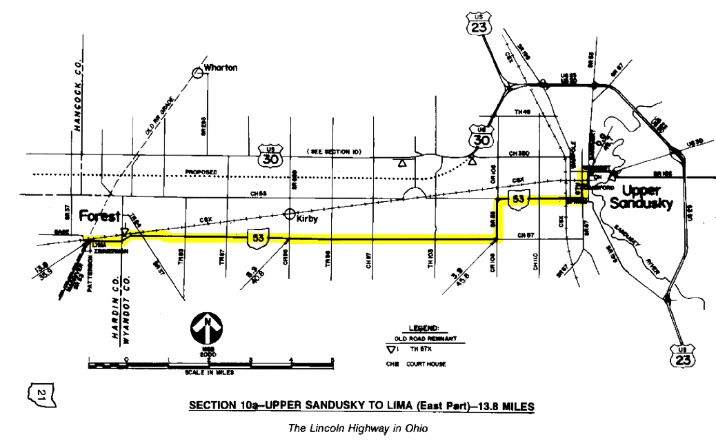 45.8—Turn Left, continuing with State Route 53
46.8—Turn Right thru sharp curve with State Route 53
48.9—At traffic signal, turn Left onto Eighth Street, continuing with State Route 53
49.5—Turn Right onto Wyandot Avenue, continuing with State Route 53;
(note: Crawford Street and Sandusky Avenue may have been part of original route)
49.7—CONTROL STATION at UPPER SANDUSKY is at the traffic signal at the intersection of Sandusky Avenue (see also, Section 9 chart)
SECTION 9a--UPPER SANDUSKY TO BUCYRUS via Nevada
0.0—Continue easterly with Wyandot Avenue/State Route 182
0.2—Brick pillar replica at Right, at southeast corner of Fourth Street
0.65—Turn Right, continuing with State Route 182
0.8—Turn Left, continuing with State Route 182
8.0—At stop sign in Nevada, turn Right onto State Route 231/Morrison Street
8.3—Avoid State Route 231, which diverges Left; continue southerly with Morrison Street
8.5—At stop sign, turn Left onto Center Street
8.6—At stop sign in downtown NEVADA, continue easterly with Center Street, which becomes Township Road 55 outside corporation, then Nevada-Wynford Road in Crawford County
14.6—At flashing red signal, turn Right onto Lincoln Highway; enter Bucyrus on Mansfield Street
16.9—CONTROL STATION at BUCYRUS is at the traffic signal in Washington Square, at the intersection of Sandusky Avenue; reset odometer to zero (see also, Section 9 chart)
SECTION 8a--BUCYRUS TO GALION 11.5 MILES
0.0—Bear south with Sandusky Avenue/S.R. 4/S.R. 98 for three blocks
0.2—At traffic signal, turn Left onto Charles Street for one block, diverging from state routes
0.3—At traffic signal, turn Right onto Walnut Street/State Route 19 for one block
0.35—At traffic signal, angle Left onto Hopley Avenue, continuing with State Route 19; the gas station at this corner was the location of the John E. Hopley home; his address was #1 Lincoln Way (renamed Hopley Avenue)
1.5—Original location of brick pillar known as Songer Marker was at Right; the pillar is now at the Stewart Cemetery east of Bucyrus (see Section 8)
 2.7—Holmes Curve; there once was a brick pillar in front of the brick house at Right
3.2—Avoid State Route 100, which diverges Right; continue easterly with State Route 19
5.1—Colonel Crawford Battle Monument, and historical marker for Seccaium Indian village, at Left
10.6—At traffic signal, angle Left onto Harding Way, continuing with State Route 19
10.8—At traffic signal, junction with S.R. 309; continue east with state routes and Harding Way
11.5—CONTROL STATION at GALION is at the traffic signal in the square, at the intersection of Market Street; reset odometer to zero
SECTION 7a--GALION MANSFIELD 15.3 MILES
0.0—Continue easterly with State Route 309/Harding Way
0.6—Where S.R. 309 diverges, continue east with Harding Way
1.4—Turn Left onto Gelsanliter Road to return to State Route 309
1.8—At stop sign, turn Right, resuming with State Route 309
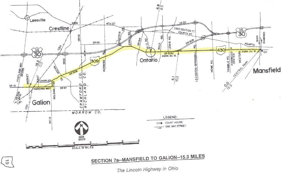 8.5—ONTARIO
9.9—Continue east onto Park Avenue West/State Route 430, diverging from State Route 309
15.3—CONTROL STATION at MANSFIELD is at the traffic signal at the west side of Central Park, at the intersection of Main Street; reset odometer to zero (see also, Section 7 chart)
SECTION 6a--MANSFIELD TO WOOSTER via Ashland 35.1 MILES
0.0—Continue easterly with Park Avenue West/State Route 430
0.05—In median of Park Avenue East is a concrete post replica set in April 1996
0.1—Richland County Court House at Right
0.5—After passing under the railroad bridge, bear northeasterly with U.S. Route 42/Ashland Road, diverging from State Route 430
2.3—Lincoln Inn at Left, in local development known as LINCOLN HEIGHTS
2.9—Interchange with four-lane U.S. Route 30 (Mansfield Bypass)
4.6—Angle Left onto Windsor Road , which becomes Township Road 1688 in Ashland County; an interesing 2.3-mile diversion
5.6—Mail Pouch barn at Right, in community of WINDSOR; L.H.A. member Richard Taylor had the barn painted as an anniversary gift to his wife Mary Lou; painted by Harley Warrick, last of the Mail Pouch barn painters
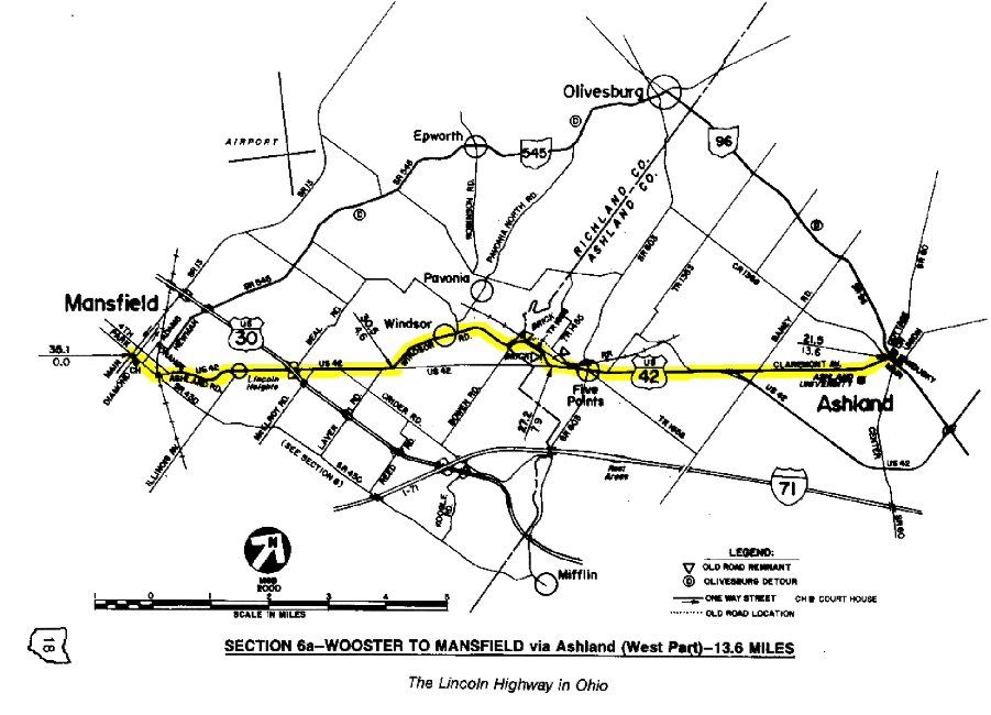 7.2—Old brick road remnant at Left, at outside of present curve in road
7.8—Old brick road remnant at Right , was grade for old overpass of interurban
7.9—At stop sign at U.S. Route 42, Turn Left, resuming northeasterly with U.S. Route 42
8.4—FIVE POINTS
10.9—Continue northeast onto Claremont Avenue, diverging from U.S. 42, which bypasses Ashland
13.6—At traffic signal in downtown ASHLAND, turn Right onto Main Street/State Route 96; Ashland County Court House is one block north of this point
15.2—Junction with U.S. Route 250; continue easterly, now with U.S. Route 250
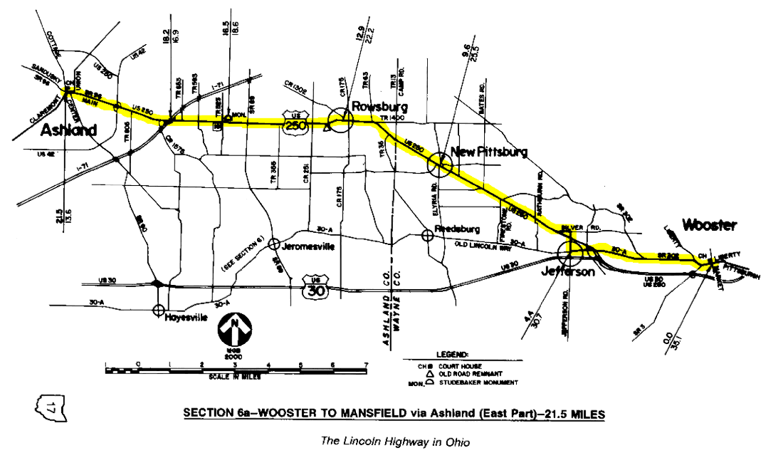 18.6—Studebaker Monument at Left
21.7—Old brick road remnant, now part of driveway at Right
22.2—ROWSBURG
23.1—Curve Right, continuing with U.S. Route 250
25.5—NEW PITTSBURG
29.7—Opposite Christmas tree farm, turn Left onto Silver Road, leaving U.S. 250
30.1—Curve sharply Right onto Jefferson Road; curve is locally known as Dead Man's Curve
30.3—At stop sign, cross four-lane U.S. Route 250 and continue with Jefferson Road
30.7—At stop sign in JEFFERSON, turn Left onto County Road 30-A/Old Lincoln Way
31.4—At stop sign and red flashers, again cross U.S. Route 250, continuing easterly with County Road 30-A/Old Lincoln Way
34.5—At traffic signal, angle Right onto Liberty Street, also with State Route 302
35.1—CONTROL STATION at WOOSTER is at the traffic signal in the city square at the intersection of Market Street; Wayne County Court House is at northwest corner; reset odometer to zero and resume with charts at Section 5