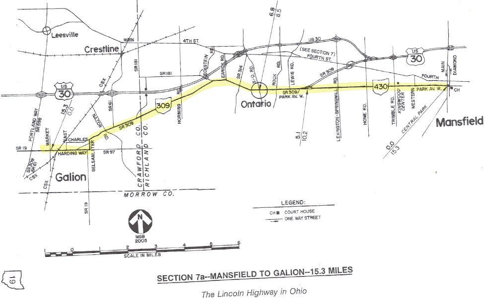
SECTION 7a—MANSFIELD TO GALION—15.3 MILES
Between 1913 and 1920, the route of the Lincoln Highway was from Mansfield to Galion, following most but not all of today's State Route 309. Both cities were on the route of Main Market Route No. 3, which connected nine county seats as it crossed Ohio. Although not a county seat, Galion was then a city of about 8200, and became an important junction point for both highways and railways.
At Galion, the coast-to-coast tourist of the 1910s had a choice of two different routes to proceed west. Of course, one choice was the Lincoln Highway. The second choice was the Marion Way, which eventually became the Harding Highway. The Marion Way included that same portion of the market route between Galion and Lima which had been so quickly removed from the originally proclaimed Lincoln Highway route in 1913, a story which is more completely told in Section 10a.
The spirited efforts of citizens in Marion and Kenton to get back on the Lincoln Highway began a rivalry between northern route and southern route cities that essentially continued until 1973. It was in that year that the state finally did away with the 30-N and 30-S designations, assigning the current U.S. Route 30 and State Route 309 numbering that exists today. The old combination of numbers and letters were created in May 1931, when State Route 5 between Mansfield and Delphos had been improved enough to merit a federal designation. The northern route of State Route 5 thus became U.S. 30-N, and the southern route, which in 1926 had ironically become the original route of U.S. 30, became U.S. 30-S. At a time when federal aid was much coveted for the improvement of major highways, everyone on the two routes would benefit from this dual designation. By the time the northern route did assume the present designation of U.S. 30, many sections of old 30-N had become four-lane limited access highways. This was especially true west of Beaverdam, but bypasses were also in place at Bucyrus and Mansfield.
Leaving downtown Mansfield via today's State Route 430, the early route of the Lincoln Highway meets State Route 309 within the town limits of Ontario. Route 309 continues westerly through the center of the original community, then turns southwesterly toward Galion. The old town center of Ontario is certainly a quiet contrast to the suburban sprawl annexed with the automotive plant and shopping center along Fourth Street.
At the east side of Galion, the earliest routes did not follow what is now State Route 309. Instead, a diversion is necessary at Gelsanliter Road to stay with those first routes, meeting Galion's Harding Way about one-half mile east of its present junction. Harding Way was originally Main Street in Galion, and was known as Lincoln Way during those years when the historic transcontinental route passed through town. Post cards from this era often feature the same street scene, but with different highway names.
Galion is one of only three locations in Ohio (or anywhere in the U.S.?) where variations of the Harding Way name are in legal use for a city street or a rural roadway. In both Marion County (Marion) and Allen County (Lima), portions of State Route 309 are officially designated Harding Highway. Galion appears to be the only place with a Harding Way. In 1931, a brochure was published which described a Harding Highway route from Pittsburgh to Denver, and it would be interesting to find out if there are any other streets on the route that adopted the Harding Highway or Harding Way name.
Today, Galion remains an important junction point for two former Big Four/New York Central Railroad properties that are now part of the CSX system. The classic old station downtown is a lasting reminder of the city's proud railroad heritage. Look for the "C.C.C.&St.L." lettering above the doorway of the station, the abbreviation of the Big Four cities—Cleveland, Cincinnati, Chicago, and St. Louis.