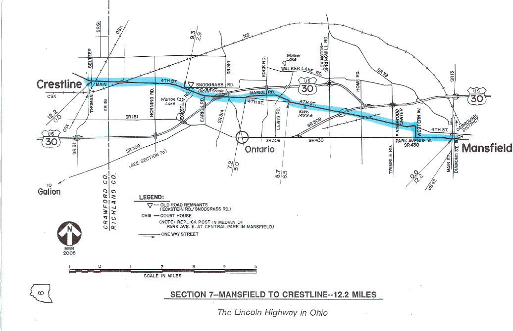
SECTION 7—MANSFIELD TO CRESTLINE—12.2 MILES
The route of the 1928 Lincoln Highway between Mansfield and Crestline includes both the halfway point and the highest point of the route across Ohio. The halfway point of this charted course of 241.4miles is on Mabee Road, near the Rock Road intersection. Not far away, only 1.5 miles to the east, and at the front of the automotive plant, is the highest point in Ohio on the Lincoln Highway—at an elevation of about 1422 feet above sea level.
Some sources have been misleading in describing this high point on Ohio's Lincoln Highway. Those references seem to suggest that this point is also the highest point in the entire state, which is certainly not the case—that distinction goes to Campbell Hill, elevation 1549 feet, near Bellefontaine. Crestline, though, is still appropriately named, deriving its name from its position near the watershed line which separates the areas draining to Lake Erie from the areas draining to the Ohio River.
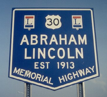 This is a memorial highway sign that is approved by the Ohio Department of Transportation. By regulation, it can only be placed at a roadside rest area.
It is also at Crestline that we can truly begin to appreciate the Lincoln Highway's close relationship with the old Pennsylvania Railroad. This relationship is not only found in the Buckeye State, but also in much of Pennsylvania and Indiana. From Crestline, Ohio, west to Valparaiso, Indiana, most of the larger towns on the Lincoln Highway/U.S. Route 30 were also stations on the Pennsylvania Railroad. In western Ohio, the cities of Bucyrus, Upper Sandusky, Delphos, and Van Wert were all stations on the routes of both the highway and the railroad. In Indiana, the cities of Fort Wayne, Columbia City, Warsaw, and Plymouth, all shared that same distinction, after a major route change in 1928. The earlier route of the Lincoln Highway in Indiana had passed through the northernmost part of the state, through Goshen, Elkhart, and South Bend.
In eastern Ohio, this relationship between highway and railroad was not quite so prevalent, but it still should be considered. The Pennsylvania Railroad, bearing westerly from Pittsburgh, was built to the north of Lisbon, passing instead through the cities of Salem and Alliance on its way to Canton. Not coincidentally, a detour route described in the 1924 Guide between Rochester, Pennsylvania, and Canton, Ohio, passed through those same two stations on the line of the railroad. Between Canton and Crestline, the railroad, like the highway, does pass through Massillon, Wooster, and Mansfield. However, the railroad does tend to take a much more winding route to get to where it is going, owing simply to the problem of creating passable grades in a hilly landscape.
Crestline is still today an important railroad town. Until recently, it had been a junction point for two lines of the Consolidated Rail Corporation, popularly known as Conrail. However, in 1999 most former Conrail properties came under the ownership and operation of either CSX Transportation or Norfolk Southern. The line which is over passed just east of town (overpass built about 1939) had been the Pennsylvania Railroad's line between Pittsburgh and Chicago, and also the route of the New York to Chicago (and vice versa) passenger train known as the Broadway Limited. The line that is crossed at grade near downtown Crestline was New York Central's Big Four line. The Big Four was the nickname for the Cleveland, Cincinnati, Chicago and St. Louis Railroad, and at Galion—only five miles down the track and the home of a classic old railroad station—this railroad divided into a Columbus/Cincinnati route and an Indianapolis/St. Louis route, both of which are still important routes today.
Crestline has one of the prettiest business districts along the route, including two treasures on Seltzer Street. Inside the post office, there is a mural which features a Pennsylvania steam engine meeting a New York Central steam engine. North of the post office is Holcker's Hardware, where oak bins line the walls, sliding ladders are used for access, and an old-fashioned tin ceiling remains in place.
Aside from the railroad, the impact of suburbia is also quite apparent on this section of the Lincoln Highway. Ontario, which was an unincorporated community of just 250 people at the time of the 1918 Guide, is now an incorporated town with a population over 4000. It is home to the major shopping areas of suburban Mansfield, and now that the area of the automotive plant is within the corporate limits, it is the highest town or city on the Lincoln Highway in Ohio. Coming westerly from Mansfield, the maze of stoplights, streets, and stores makes it difficult to tell where Mansfield ends and Ontario begins. For those who are curious about such things, the corporation lines are common at Home Road.
Historically, this section of highway was part of a road laid out in the 1820s between the county seats of Mansfield and Bucyrus. Despite that, the part of the road between Mansfield and Crestline was a late addition to Ohio's system of Inter-County Highways, as indicated by its high number—I.C.H. #501, or Mansfield-Crestline Road. Likewise, this section was also a late addition to the route of the Lincoln Highway. In December 1920, the route from Mansfield to Bucyrus by way of Galion was abandoned in favor of this route by way of Crestline. Later designations for this route were State Route 5 and U.S. Route 30-N. Only the western part of this section has ever carried the pure U.S. 30 designation.
Originally, U.S. Route 30-S (the previous designation of State Route 309) met U.S. Route 30-N in downtown Mansfield, but as different phases of the four-lane routes were built, this junction point moved to locations now in Ontario. The last four-lane segment of U.S. Route 30 to be opened in this area was the "Ontario Bypass" in the late 1970s. This route diverted traffic away from the busy areas near the shopping center and auto plant, and connected with the existing "Mansfield Bypass." In November1973, the route marked U.S. 30-S was renumbered State Route 309, and U.S. 30-N was assigned the U.S. 30 designation.
As a result of the reconstructions and realignments which preceded the limited access highways, there are two remnants of the 1928 route of the Lincoln Highway in this section which are not part of the Fourth Street route. One of these remnants is the 1.5-mile parallel road now known as Mabee Road, which was bypassed as a result of a relocation and reconstruction of U.S. Route 30-N in the early 1950s. Mabee Road is a relatively safe and pleasant departure from the "main" road in Ontario, and is therefore part of the charted course.
Another short "L"-shaped remnant—only one-half mile long—is now part of Eckstein Road and Snodgrass Road. This remnant was created as part of a U.S. 30-N improvement project in the mid-1930s. However, because it is so short and admittedly uneventful, this old alignment is not part of the charted course. The old trolley bed on the south side of Snodgrass Road is the only point of interest along this possible diversion. Ironically, a second improvement in the early 1950s destroyed the short relocation built in the mid-1930s.